
After the discovery of gold near Bathurst, NSW in February 1851, a gold discovery committee was formed by the Victorian Governor in the hope of ending the mass exodus of the population from the new colony. A £200 reward was offered for the discovery of gold within 200 miles of Melbourne. As gold had already been found there were a number of claimants and who was first is still a matter of dispute. The reward was divided up and it appears that the first acknowledged find was not far from the Mullum Mullum Creek.
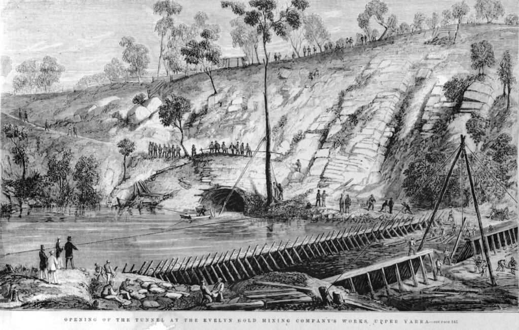
Reported as a find at Deep Creek (Mullum Mullum Creek), the actual discovery was in Andersons Creek in Warrandyte. In 1935 a cairn marking the site of the first discovery of gold in Victoria, was erected at the creek on what is now called Gold Memorial Road. Naturally people rushed to the area in the hope of finding their fortune, and just as quickly rushed on to the next site when pickings proved scarce. Over the next 50 years or so mines were dug and then abandoned. The most well known engineering feat is the Pound Bend tunnel, dug in 1870 to divert the flow of the Yarra River to allow the river bed to be worked for gold.
All through the gullies and hills around Warrandyte there is evidence for the search for gold. The 1893 Geological Survey held by the State Library of Victoria shows numerous quartz reefs and workings near the point where my Mullum Mullum Creek walk resumes. The circled 19 on the map indicates a specimen held at the Department of Mines and it is where I start.

The landscape around the section of the Mullum Mullum Creek west of Park Road still contains evidence of gold prospecting .

Somewhere on this steep slope leading up to McIntyres Road is a Heritage Listed Adit. This is a tunnel going into the hill and the heritage listing confirms it is a gold mine, possible going in about 50m and then a vertical shaft of unknown depth. It is assumed the miners were following gold in a quartz vein. There is also evidence of a path, a culvert and quarrying on the bank of the creek. All this is very overgrown and the adit is on private land.

The bank of the creek is obviously very susceptible to erosion and damage. Because of all the previous activity in the area, the original course of the creek is unknown.
Fortunately a board walk takes the trail through this part of the creek valley.
The the valley opens out a little, and getting closer to Tindals Road there is a new residential development with large lots and a respect of the natural environment.


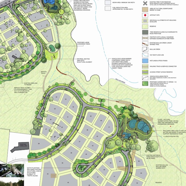
Designed to preserve existing Manna Gums, Yellow and Red Box and Candlebarks, the Mullum Creek estate also has building design guidelines to …promote high-quality, attractive homes that will meet high standards of environmental performance.
The project won the Best Natural Built Environment Award in the Victorian Landscape Industry Awards 2018 with the Judge’s comments – “The project at Mullum Creek in Donvale is a fantastic exemplar of a natural built landscape. The hydrology and ecology of the site has been well-considered, with runoff from the development site treated by a constructed wetland before it enters the nearby Mullum creek. Indigenous plantings have extended the remnant vegetation into the landscape and wetland, from seed previously collected from the site. Furniture, fences and bollards were milled on-site from timber that was already on the property. Much thought has been put into making the Mullum Creek development a beautiful, sustainable landscape.”
From the trail there are pleasant views of the wetlands and the interesting homes, some with very expensive landscaping. At Tindals Road again the route is uphill to a safe crossing and then down to the creek again.

Suburban development is very much in evidence on the south of the creek where the trail intersects with a number of streets and courts. On the north side it has remained open land, so that is the route I took.


This path goes through an area that was used for equestrian cross country events. The council purchased an adjoining old orchard for extra space and then negotiated with the riding club to exclude horses from the vulnerable wetlands and creek banks. A board walk was installed to further protect the area.

But of course you can’t stop kids doing what they have done for eons. Mucking about at the creek. As I followed the path above the creek I could here shouting and laughing and general daredevil carrying on. I couldn’t see anyone though. Then at last I spotted the schoolboy on the other side of the creek. His mates were under the rim of the bank on my side, trying to walk along the very edge of the water without slipping in. One was worried about his shoes and how could he go back to class all muddy. They were in uniform, from Donvale Christian School that is not that far from this spot, just back a bit and up the hill. So this is private school number three on Mullum Mullum Creek.
If I had been on the other side of the creek, following the Mullum Mullum Trail I would have seen the next school. I did on my return trip. Have I mentioned that because I drive to my start point I walk every section twice? I try to find a different route as I did on this day, but it is not always possible.

Through the trees you can see the Donvale Junior School campus of Carey Grammar. It has an interesting history. Way back in the early 1970s when I was a student teacher there was growing interest in alternatives to the traditional school. A. S Neill’s Summerhill in the UK was the exemplar we studied. In Melbourne a group of parents decided to create the first alternative secondary school in Australia. It was called Era, standing for Education Reform Association: – a little from http://www.era-school.net

The most obvious difference between Era and traditional schools was the relaxed disciplinary environment in which students could wear what they want, call teachers by their first names, attend only classes of their own choosing (or none at all ) and take part in much of the school’s decision making process.
After the school closed in 1987 due to financial difficulties the site was purchased by Carey – a school in Key with no Yarra River frontage for rowing practice; perhaps they thought creek frontage would be good enough. (This is a reference to an old rivalry between this school and its sister school that I attended which had purchased a Hawthorn property on said river when I was there.)
Back to the Trail. The valley is now quite wide, a large almost flat area is Buck Reserve, home to the Donvale and Templestowe Pony Club.


No meeting on the day I was there, so I could take a path through the reserve as the way by the creek was very muddy. I discovered later that the club house was not originally on this site, it didn’t look like it would have been an old orchard home.


The creek just before it goes under Reynolds Road and a tree by the foot bridge. Marvellous.
As I joined the Mullum Mullum Trail once more I saw the section I had missed is all hard paved with mown lawns and skirts a large carpark and indoor sports stadium. I was very glad I had taken the less travelled route.

Fabulous history account of that section of the creek. There is certainly a lot more to it than just a creek running through properties.
The plans for the new estate look much better than most! But that comes at a cost of course. I see a couple of the blocks are currently for sale, for $1 and $1.2 mil. It will be interesting to see if the homes built really are in keeping with the environmental philosophy expressed by the planners.